

Last Sunday (the 25th September), after watching some planes take off, I was on my way to the actual adventure of the day - climbing Montagne Lion. After conquering the 812m of Le Pouce twice, I couldn't wait to climb Lion Mountain & it’s paltry 480m!
I mean, how hard can it be?

We started the trek by getting lost!

The 3 worst explorers in history, dumped in the middle of nowhere...


Utterly bewildered by everything!


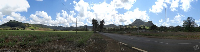
Lion Mountain was in front of us, but we had absolutely no idea where we were...


100m ahead, we found out that we had landed at Ferney.

As it turned out, due to some misunderstanding, we had been dropped quite a way off from the starting point. Sadly, we didn't have the above map with us to know that. The map I had only showed the beginning of the trail.
Using the GPS on my N900, I figured out that all we had to do was to keep following the road & eventually we would reach the starting point.


At the entrance of La Vallée de Ferney, next to this colonial-styled house, there was this monument.


In this locality, on 8th November, 1639, Adriaan Van Der Stel released deer imported from Java on board the "Capelle" (Cervus Timorensis russa).
Interesting. So this is where the doom of the dodo started...

Beware... dancing cars ahead!

Beware... keep hold of your umbrellas!

Further down the road, we caught sight of another monument.

This plaque was unveiled on Sunday 20 September 1998 by His Highness Prince Maurits Van Oranje-Nassau of The Netherlands in commemoration of the 400th anniversary of Dutch landing in Mauritius.


Commemorating the introduction of sugarcane in Mauritius in December 1639. The root of diabetes in Mauritius.
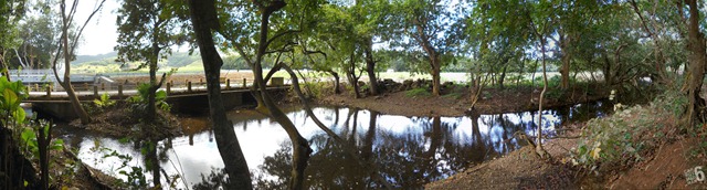
This Dutch monument was located near an unknown river.


Along with two bridges, one old & a newer bypass.

& at last we had visual confirmation that we were on the right track. A sign announcing that we were now in Old Vieux Grand Port.


Lion Mountain was straight ahead & we could have easily cut through the fields but we decided to stick to the road as we didn’t want to get lost again…


Soon we entered the village of Treize Cantons in Vieux Old Grand Port. A typical fishing village with the locals going about their Sunday routine – some attending Mass, others returning from the market, a few playing loud music, kids attending tuitions, the old folks playing domino/cards under trees while the younger ones enjoying their bottles of Phoenix beer.

It wasn't long before we saw yet another relic - Tour des Hollandais.


Contrary to what it name suggests, this watch tower isn’t Dutch.

TOUR DES HOLLANDAIS - Remains of an old watch tower from the French period. Renovated by The Grand Port Savanne District Council...


We were so caught up taking photos that we almost trampled this nasty spider!

100m down the road, we came across the biggest historical artifact of Vieux Old Grand Port.

The Fort Frederik Hendrik.

It was here that the Dutch (1638) & the French (1722) settlements were first established.


Sadly, we didn’t have time to visit the museum, so we took photos of the ruins.


The Lodge.

It was here that we had our first view of the sea.

The bay of Grand Port.

Ile Marianne (behind the trees) & Ile aux Fous.

Ile aux Fouquets, Ilot Vacoas & Ile de la Passe.

Ile aux Fouquets & its lighthouse.

Ile aux Aigrettes.

Ilot Chat & Ile aux Singes.

Boat race at Mahebourg. See Régates à la Pointe des Régates 1 & 2.


After leaving Fort Frederik Hendrik, we finally arrived at our starting point, the Old Vieux Grand Port police station. It was 11:10 am, we had already walked 3.5km & yet we hadn’t even started climbing Lion Mountain.
Instead, we had been walking through the cradle of Mauritian history. Vieux Grand Port is where Mauritian civilization was started by the Dutch, who gave us many things – sugarcane, deer, the name Mauritius & the world’s most famous…. extinct animal, the Dodo.

The tale of the actual climb will come in part 2, but for now, check out these links below for photos of some of the historical sites we couldn’t visit…

Note: The non-watermarked (& better) photos were taken with my friend’s Canon SX130 IS.
Related:
- Red Needle's Tropical Passions – Hiking from Ferney to Devil's Point - Part 1
- Red Needle's Tropical Passions – Hiking from Ferney to Devil's Point - Part 2
- Red Needle's Tropical Passions – The First Dutch Landing
- Mauritius Photography Blog - Ferney snapshots
- Mauritius Photography Blog - Pointe du Diable (Devils Point)
- Mauritius Photography Blog - Bois des Amourettes snapshots
- the fl-Og - 200km Trip on Motorcycle – Haojue 125
- Maurtian Spoken Here – L'îlot Chat et l'île aux Singes
- Gov.mu – The Vieux Grand Port Heritage Site
- Flickr – Old Grand Port by timaaa
- Flickr – Grand Port by rubared
- Flickr - Île Maurice (Vestiges Historiques)
- Flickr - Dutch Landing Monument
- Flickr – Dutch Landing Plaque
12 comments
:O Ilot Chat & Ile aux Singes .... oO I never heard of them. You walked all this ... :S :/
(Hmm, there's some housekeeping to be done with the above comment, but I can't see the link "edit" anymore...)
I put emphasis on the "Vieux Old" because I hate how they're 'Englishifying' it. Let it remain Vieux Grand Port.
Yes, I climbed the mountain. That would be in the next post. :)
You have to login in Disqus to be able to edit.
How to do this?
It seems I am logged but I still can't see how to edit my first comment.
" Let it remain Vieux Grand Port."
How do you say that in Dutch?
"Haven van Warwijck."
:)
"The tale of the actual climb will come in part 2"
Kinn arivé ? Inn tom dan trou ? Inn tas lor sek ? Inn gaign mordé ar lisien ?
:LOL:
1. Mo pas ti ena Internet pendant 5 jours!
2. Mo backup hard disk p mort! Managed to copy all photos except those of Lion! Eventually, I got the pics, so the post is coming soon... :)
Ah. There's a part 2 coming. I was asking myself if you really succeeded in climbing the mountain as it seemed that it was more of a visit about the first colonization of the island.
"A sign announcing that we were now in Old Vieux Grand Port"If the name of this place contains both old and vieux, then it must be almost prehistorical. Has any artifact from some cavemen been found there? (Again, who on Mars talk of "Old Grand Port" when he or she goes to that place? "Englishifying" the placename doesn't make any sense — nor "Frenchifying" or "Creolifying" them either, as nobody has ever heard of "Colline Rose", "Nouveau Verger" or "Bon Laterre".)
The photo of île aux Mariannes and île aux Fous is great: it really looks as if the islands are floating above water. A lovely effect of refraction.
"Ile aux Fouquets & its lighthouse."Here is a picture taken through a window in the lighthouse itself, which is built on a coral island home to funny spineless sea urchins.
So, in the end, did you manage to reach the top of the mountain without falling off a precipice?
Post a Comment